The Glass House Mountains field trip is a project-based learning (PBL) instructional model that helps the year 9 students, who are studying Earth Sciences, to learn about the formation of the Glass House Mountains, how hot spots cause changes in volcanoes over time and the geological activity in Australia. Furthermore, the Glass House Mountains field trip is a good way to understand better the theory of the tectonic plates and continental movement. By the end of this project, the students will be able to describe the movement of the tectonic plates, explain how hot spots cause volcanoes, and infer the location of the hot spots, based on the age and location of the volcanoes in Australia.
What will the students
learn?
One of the most important objectives of the project-based learning (PBL) pedagogy is to help students develop real-world skills, such as learning and innovation skills, digital literacy skills, and career and life skills. Students will develop 21st century skills, such as critical thinking and problem solving skills, communication, collaboration, creativity and innovation. In addition, students will learn how to use technology with purpose, how to conduct research online, use spreadsheets to organise primary and secondary data, and video editing and presentation software tools. Furthermore, they will develop their career and life skills, such as social, leadership, adaptability, flexibility, self-direction and responsibility skills. Susan McCray argued, “I can’t imagine designing the curriculum that I do without to be able to click onto the Internet and get all the materials and resources that are available, and I can’t imagine may students not to do that either.”
In mathematics, students will learn how to
analyse patterns and trends in data, interpret maps and diagrams, and calculate
the elapsed time between the formation of a seamount and a volcanic island. Timeline andunits are introduced, such as Ma (Millions of year, cm/year). The
students will develop their numeracy skills. In science,
students will learn new concepts, such as hot spots and hot spots volcanoes. In technology,
students will learn how to conduct research online about hot spots volcanoes,
and how to create and organise data into a database.
Bybee (1997) suggested an instructional teaching
and learning model, named the 5 E’s model, which comprises of five phases, such
as engagement, exploration, explanation, elaboration and evaluation.
Engage
Once the students arrive at the Glass House
Mountains site, ask them what they know about tectonic plates and volcanoes and
help them to make connections between the moving tectonic plates, magma,
convection currents and hot spots. How did the Glass House Mountains (GHM) form?
Is Australia situated near the tectonic plate’s boundaries? Ask the students to
make inferences about how the GHM looked like 27million years ago. Where is the
Australian continent situated in relation to the plate’s boundaries? What is a
hot spot? At this stage, students receive a field trip booklet and they start
researching answers.
From the lookout point, students sketch and label
the panoramic vision of the GHM in their scaffolded booklets, and read the
information from the boards. They work in groups, share ideas and make deductions
from evidence and reasoning how the GHM looked 27 million years ago. The
information centre gives the opportunity to students to explore the geology
legend (aboriginal legend) and the history of the GHM. Moreover, they are
exposed to the majority of the scientific information about the formation of
the GHM on the walls, have access to interactive digital screens, leaflets, and
can ask questions.
The Glass House Mountains – The Magma Intrusions during the Tertiary Period
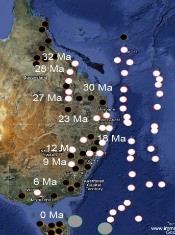
Students work in groups, use the leading questions to formulate their own questions, search for answers and try to locate the relevant information necessary to answer their own questions. They start thinking as scientists, try to work out how to identify the current location of the hot spot under the Australian plate and share their ideas with each other. In order to identify the current location of the hot spot, students will be given a map (the map below) and asked to consider the direction of the movement of the Australian plate, the location of volcanoes, and the age of volcanoes. After they identify the current hot spot under the Australian plate, students will be able to measure, on the map, the distance from the hot spot to Brisbane, and then calculate the speed of the moving tectonic plate by using the formula speed = distance/time (cm/year).
The active, dormant and extinct volcanoes on the Eastern Coast of Australia
Explain
The concept of tectonic plates was introduced in
1960’s by a group of geophysicists from America, Canada and UK to expand the
hypothesis of the notion of continental drift and seafloor spreading. According to the
theory, the lithosphere
is the outer rigid layer of the Earth, which is approximately 100 km thick. The lithosphere
is divided into seven large continental and oceanic plates and several medium
and small ones. These tectonic plates float on top of a viscous layer of molten
rocks called asthenosphere. The plates
move, at approximately 5 to 10 cm per year, towards each other forming
convergent boundaries, away each other forming divergent boundaries, and slip
past each other forming transform boundaries. The movement of the tectonic
plates are responsible for most of the seismic and volcanic activities.
Mountain ranges are formed when the tectonic plates converge (collide) with
each other whereas, the oceans are formed when the tectonic plates diverge
(move apart) of each other.
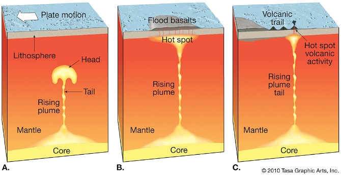
The movement of the tectonic plates may happen because of the convection currents.The concept of theconvection currentsis quite easy to understand. However, the introduction of this concept can be quite challenging. Convection currents can be explained by using the particle theory and density. When a substance is heated, the particles get excited and (on average) become further apart. This means the substance will become less dense. Thus, this will cause it to float. Once floating on the surface, it is away from the source of heat, and will start to cool down (become more dense), thus it will sink back down. The process will repeat again. A volcanic hot spot forms from mantle plumes. Mantle plumes are large bodies of extremely hot magma that are rising from the Earth’s core and resting on the underside of the Earth’s crust. These plumes increase volcanic activity on the Earth’s surface. Hawaii and Australia have examples of this.
Most of the volcanoes occur close
to the plate boundaries or at the plate boundaries. There are also locations of
anomalous volcanism, with volcanoes forming far from the plate boundaries, and
refer to as hot spot volcanoes. A new volcano can be formed when the plate,
which cover the surface of the plume, moves away from the hot spot. The volcano formed before cools to become
dormant and eventually extinct. This process forms a volcanic chain, such as
the GHM Hawaiian Islands. Volcanoes are rare in Australia
because there are no plate boundaries. However, there are two active volcanoes
in Australia: Heard Island and the
nearby McDonald Islands. Watch the following video:
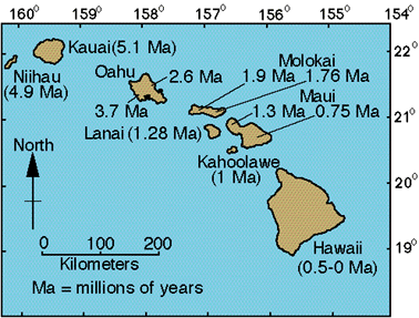
Elaborate (Reflect) Students apply the understanding of the moving tectonic plates to new situations, such as the Hawaiian Islands. Further, west of Hawaii, there are seamounts, which no longer form islands. Students analyse the pictures below and describe the movement and direction of the Pacific plate, and calculate the speed that the Pacific plate is moving in cm/year. They will be able to explain why there are only seamounts and no islands west of Kauai and identify the current location of the hot spot. This activity provides opportunities for students to apply what they have previously learned and develop a deeper understanding of hot spots concept.



 The Glass House Mountains Field Trip